Bryce Canyon National Park
UT · National Parks

Bryce Canyon National Park

A high-elevation amphitheater of orange and pink stone hosting the densest collection of hoodoos in the world.

9,115' Highest Point
36k Acres
65+ mi Of Trail
1928 Established

Our Take

Dustin and I visited Bryce Canyon on our very first trip we ever took together. It's where I learned Dustin is a mountain goat that goes straight up switchbacks like it's nothing, and where I learned that I get elevation sickness. It's also where I learned Dustin would tolerate my grumpiness at switchbacks like a champ, take care of me when an elevation migraine hit like a train later that day, and that he was going to be a keeper. And here we are, 9 years, one six year old, and twenty-some national parks later embarking on a whole year of park adventures to bring this site to life, so it was only natural to revisit it again with our son this year.

Situated between Zion and Capitol Reef, Bryce Canyon is a park we happily return to time and again: It's a fantastic stop on its own, paired with Zion, or as part of an epic Utah Mighty 5 road trip. Bryce Canyon is definitely a park you need to get out of the car for, though, because you'll never see the amphitheater from the road. When you drive into the park you'll be surrounded by rugged pines on either side, and that view will stay with you for the entire "scenic drive" until right at the end near Rainbow Point where it starts to open up. This is because you're driving along top of a plateau, and to really see the canyon you're going to need to pull into the overlook parking lots and walk out to the rim. For the main amphitheater, which you absolutely don't want to miss, you'll need to stop at Inspiration, Bryce, Sunset, or Sunrise Point (in our order of preference). These are all accessible by the shuttle, while overlooks further down the scenic drive will require your own transportation.

The Rim Trail is fantastic to explore if you're short on time, but the best way to experience Bryce Canyon is to hike down into the amphitheater on one of its many trails and walk alongside the towering hoodoos. Queens Garden, the Navajo Loop, and the Peekaboo Loop are our favorites, whether you're doing them individually or part of a large figure eight. Just know that the heads of these trails will start off crowded as many people explore the early descents, but it'll get quieter the further out you go.

Top Things to Do
Watch Sunrise from Inspiration Point
Despite there being an overlook called 'Sunrise Point', we strongly prefer Inspiration Point because they give you a wider view of the full amphitheater, with Bryce Point coming in a close second. As the sun clears the horizon to the east the hoodoos light up in vivid oranges and pinks, and the contrast between the lit hoodoos and the still-shadowed depths of the amphitheater is one of the most photogenic moments in the National Park system. Arrive at least 20 minutes before official sunrise to claim a spot at the rail, dress in layers, and bring a nice warm thermos of coffee or tea. The rim is cold before the sun is up!
Hike the Rim Trail
The Rim Trail follows along the edge of Bryce Amphitheater from Bryce Point to Fairyland Point for 5.5 miles, but it's easy to do only a portion of this and the .5 stretch between Sunset and Sunrise Points is paved for accessibility. We recommend starting at Bryce Point, hiking the 2.7mi to Sunrise Point, and then catching the shuttle back to Bryce Point.
Hike the Navajo Loop / Queen's Garden Combination
If you only do one hike at Bryce, this is it. The standard route is to descend Wall Street (the steeper, more dramatic of the two Navajo Loop trails) from Sunset Point, walk through the bottom of the amphitheater past the Two Bridges and the iconic switchbacks, then loop back via Queen's Garden up to Sunrise Point — the whole thing is about 2.9 miles with around 600 feet of elevation. This route puts the steepest descent first and the gentler climb back up to the rim last, which makes it noticeably easier than running it the opposite direction. From the bottom of the amphitheater the hoodoos tower above you in every direction, and you'll pass formations like the Queen Victoria spire that you can't see from the rim.
Drive the Scenic Road to Rainbow Point
The 18-mile scenic drive runs the length of the park from the entrance to Rainbow Point at 9,115 feet. The shuttle doesn't run this section, so you'll need to drive yourself. The route passes a series of overlooks — Swamp Canyon, Farview Point, Natural Bridge, Agua Canyon, Ponderosa Canyon — each with a different angle on the plateau and the hoodoo formations. We like to drive all the way down to Rainbow Point, see the vista, and then stop on the overlooks on the way back as they’re all on the eastern side of the road making it easy to get in and out of on the way back.
Walk to Mossy Cave
A short, fee-free 0.8-mile out-and-back along Water Canyon outside the main park entrance, and the trailhead is found 4 miles east on highway 12. The trail follows a small creek (one of the few perennial water sources in the area) up to a small grotto where moss grows year-round on the seeping rock face and a small seasonal waterfall drops over a ledge. Leave your Park Pass on your dashboard at the trailhead, as this still is a fee area.
Hike the Peekaboo Loop
Peekaboo is a 5.5-mile loop that drops well below the rim and threads through the heart of the amphitheater past Wall of Windows, the Cathedral, and the Three Wise Men formations. With around 1,500 feet of cumulative elevation it's one of the more strenuous of the standard amphitheater hikes, but the payoff is hours among the hoodoos with significantly fewer people than you'll see on the Navajo or Queen's Garden trails. The trail starts at Bryce Point, and most hikers connect it with Navajo Loop or Queen's Garden to make it the longer "Figure 8" hike. Horses also use this trail, but depending on the time of day you may not encounter them.
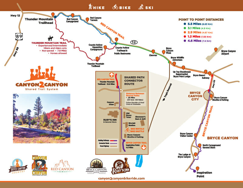
Canyon 2 Canyon Bike Trail
This 20 mile paved trail connects Bryce Canyon, Bryce City, and Red Canyon, and several companies rent e-bikes and mountain bikes to enjoy the trail. If you have kids too young for their own bike, you're looking for companies that have pull behind wagons or "rad" wagons, where they can sit on a large seat with handles behind you. While you can ride into Bryce Canyon, the "scenic drive" of Bryce Canyon is really just pine trees, so the thing to do here is actually bike out to Red Canyon and explore the hoodoos and trails in that area.
Read full guide →
Take A Guided Horseback Ride
Canyon Trail Rides offers 2 and 3-hour guided rides from the park lodge into Bryce Amphitheater seasonally between April and October. Your guides will take you down Sunrise Point and begin the descent down into the canyon, with the 2 hour ride making a loop and returning to the canyon rim, and the 3 hour ride continuing on to the Peekaboo Loop Trail. This is the only horse guided tours that take place within Bryce Canyon itself.
Read full guide →
Drive Highway 12 East to Capitol Reef
If you’re headed from Bryce Canyon to Capitol Reef (or Arches beyond), there is a shorter route that will come up on your GPS, but trust us and take Scenic Byway 12. We’ve driven numerous scenic roads in our time and this is easily one of our top five. In the first third of the drive, you may be like us and find yourself thinking: "This is…interesting…but I’m not really seeing what all the fuss is about." Keep going. After you get past Escalante, you’ll hit a very obvious point where you drive through a narrow section carved between two rock walls and immediately find yourself at the stunning Head Of The Rocks overlook, and you’ll know you’ve arrived at starting point of what makes US12 worthy of all the praise. Watch for the Kiva Coffeehouse as you go a little further down the route, it’s one of the most unique coffee shops we’ve ever stopped at and we highly recommend their iced coffees and lemonade.
Our Tips
1
Wear Sturdy Hiking Shoes With A Good Grip
A lot of the trails in the park, especially as you go into the canyon or along the rim, are going to be made up of a small crushed gravel like material that slides easily underfoot. Couple this with the ups and downs of the trail, especially in areas where you're hiking on the ridge line that slopes away on either side, and it can be easy to slip. Our first time in the park we passed someone receiving medical attention from park rangers because she had slipped on the trail and fallen hard on her tailbone. She was wearing really worn-down sneakers with no grip left, and better footwear might have saved her a ride on a stretcher out of the park.
2
Take The Shuttle 10am-3pm During Peak Season
From early April through late October, Bryce runs a free shuttle that loops from the gateway town of Bryce Canyon City through the visitor center, the main lodge, and the four main amphitheater overlooks. On busy weekends and during peak season the main amphitheater parking lots fill by mid-morning, and rangers will outright turn you away from the turn off towards Bryce and Inspiration Point so you can't even circle waiting for a spot. Don't miss the best part of the park! If you're too late to easily get into the parking lots, find a shuttle stop. One tip is that if you are trying to use the visitor center shuttle and the lot is full, there's actually an overflow lot across the street closer to the camp ground.
3
Come Prepared for Gnats In Warm Weather
Along the rim there is often enough of a breeze that the insects won't bother you, but as soon as you get down into the amphitheater on any of the trails on a warm day you run the risk of being absolutely swarmed by gnats, especially among the pines. Either accept it, and know that you may not get the chance to sit in peace at a quiet spot because they're so bad, or bring some bug spray. Natural oils don't tend to work well on gnats, so something with DEET or Picaridin (less damage to clothing/bags) is your best bet.
4
Pace Yourself For The High Altitude
The rim sits between 8,000 and 9,100 feet, which is higher than the rim of the Grand Canyon and noticeably thinner than what most visitors are used to. Every hike into the amphitheater ends with a hike back up out of the amphitheater! If you're coming from sea level, give yourself a half-day to acclimate before tackling more strenuous trails like Peekaboo or Fairyland, drink more water than you think you need, and don't be embarrassed to take breaks on the climb out. One of our mistakes on our first trip was also using Wall Street as our ascent after the Figure 8, instead of picking a more moderate climb back out, so look for ways to loop that give you a more gradual ascent back up.
5
Spend The Night To See Sunrise
Bryce's hoodoos face east, which means sunrise lights them up first and most dramatically. The rocks practically glow orange for the first half-hour after the sun clears the horizon. Sunset is pretty too, but the light is hitting the rocks at a flatter angle and the colors don't pop the same way. We prefer Inspiration Point for sunrise, but Bryce Canyon and Sunset Overlook are winners as well. Plan to arrive at least 20 minutes before official sunrise, and dress warm, because even in summer the rim before sunrise can be in the 40s. The later you get into the year, the earlier sunrise is, so we highly recommend spending the night before in the park or nearby Bryce City to give yourself an easy drive to your sunrise spot.
6
Winter Photography Is Spectacular
Bryce gets 80 to 100 inches of snow each year and seeing the orange hoodoos dusted in white against blue desert sky is one of the most unique and iconic winter scenes in the National Park system. The park stays open year-round, the main road is plowed to Inspiration Point, and snowshoe and cross-country ski rentals are available at the lodge when open. The rim trails are usually walkable in good winter boots with traction (microspikes recommended), but the descent trails into the amphitheater can be icy and treacherous so if you're not prepared for winter hiking we recommend staying above the rim.
When To Visit
Our pick: April to June.

Bryce's high elevation keeps it cooler, which mean spring gets a bit of a late start here. The park gets snow from November into April, making it difficult to plan a trip because the rim road past Inspiration Point may be closed in heavy storms, and the descent trails into the amphitheater can be too icy to safely hike from December through February. Things begin to warm up in April, but May is when the rim trails reliably clear and the hoodoo trails dry out and the wildflowers along the rim peak in June. July and August then bring seasonal thunderstorms before the temperatures start to drop again.

Average Park Visitors by Month
Temperature by Month
Cold (< 55°F)
Ideal (55-80°F)
Hot (> 80°F)
Average
How To Get There
Visitor Centers
Bryce Canyon Visitor Center
Located just inside the park entrance off UT-63, the visitor center has a film about the geology and ecology of the park, exhibits on the Paiute people who used the plateau before park designation, a bookstore, ranger-staffed information desk, and restrooms. Stop here first for current trail conditions and ranger led programs. The shuttle stops at the visitor center, and if they're out of parking spots you can take a look across the street in the overflow lot.
Entrances
1
Main Entrance (UT-63)
Bryce Canyon has a single entrance into the park, accessed via Utah State Route 63 from US-12. The entrance station is just past Bryce Canyon City and leads directly to the visitor center, the main amphitheater overlooks, and the scenic drive to Rainbow Point.
Entrance Fees
Car
$35
Motorcycle
$30
Per Person (foot/bike)
$20
Annual
70
Gateway Towns
1
mi north
Bryce Canyon City
Bryce Canyon City sits right at the entrance to the park, and is not actually a city but a tourist center anchored by Ruby's Inn. There's a sit-down restaurant, a general store, gas station, post office, and the staging area for the free park shuttle. It's a convenient base if you want to be steps away from the amphitheater at sunrise, but nearly everything is owned by Ruby's Inn and Best Western to some degree so be aware of that and know that quality can be a little mixed due to the monopoly ownership of the area.
Best for: Convenient location right outside the park with easy shuttle access, great for first timers, families, and those wanting to catch sunrise.
11
mi east
Tropic Our Pick
Tropic is a small authentic Utah town about 15 minutes from the park entrance as you head east on Highway 12, and if you're not staying inside the park itself this is a great option. Tropic houses a handful of independent inns and much better food options than you'll find in the park or Bryce Canyon City, including some really charming cabins and glamping sites. You'll also have easy access to the Tropic Trail, which is one of the best choices for solitude in the park because the trail starts outside the main visitor area and hikes into the park.
Best for: Travelers who prefer small-town character, better food options, or private cabin units. Easier access to Kodachrome Basin State Park.
Common Questions & Answers
Can I do Bryce Canyon in a day, or how much time do I need? +
Our recommended stay for Bryce Canyon is "two nights", especially if this is your first and potentially only visit. The first night gives you some time to acclimate to the elevation, and also means you're already there for the best part of Bryce Canyon: Sunrise. The second night means you really do have a full day to explore and hike the canyon without feeling rushed. Because Bryce Canyon is 2-5 hours from the typical visitor's "next stop" on their road trip, without that second night you're going to feel anxious to finish your hike, scarf a meal, and get on the road, instead of actually taking the time to enjoy your visit. Also, see the Q&A on elevation, because you may find at the end of a hike you are not ready to get back on the road...
Is the elevation a problem? +
It can be. The rim sits between 8,000 and 9,100 feet, and every hike involves descending below the rim and climbing back up at the end. If you're coming from sea level or near it, give yourself a half-day to acclimate, drink more water than usual, and pace yourself on the climb out. On our first trip out here (just Dustin and Allison, Warren was not even imagined at that point), we made the mistake of going straight from Angel's Landing in Zion the day before to do the Figure Eight (Navajo + Queens Garden + Peekaboo) at Bryce the next day. Allison bonked out really hard that night with a migraine, leading to the realization that she gets impacted by elevation sickness despite never experiencing it before. If you're not sure how you'll do at elevation, pay attention to if you're feeling more winded than you feel you should be, and that will be a sign to slow down and rest frequently.
Sunrise or sunset at Bryce? +
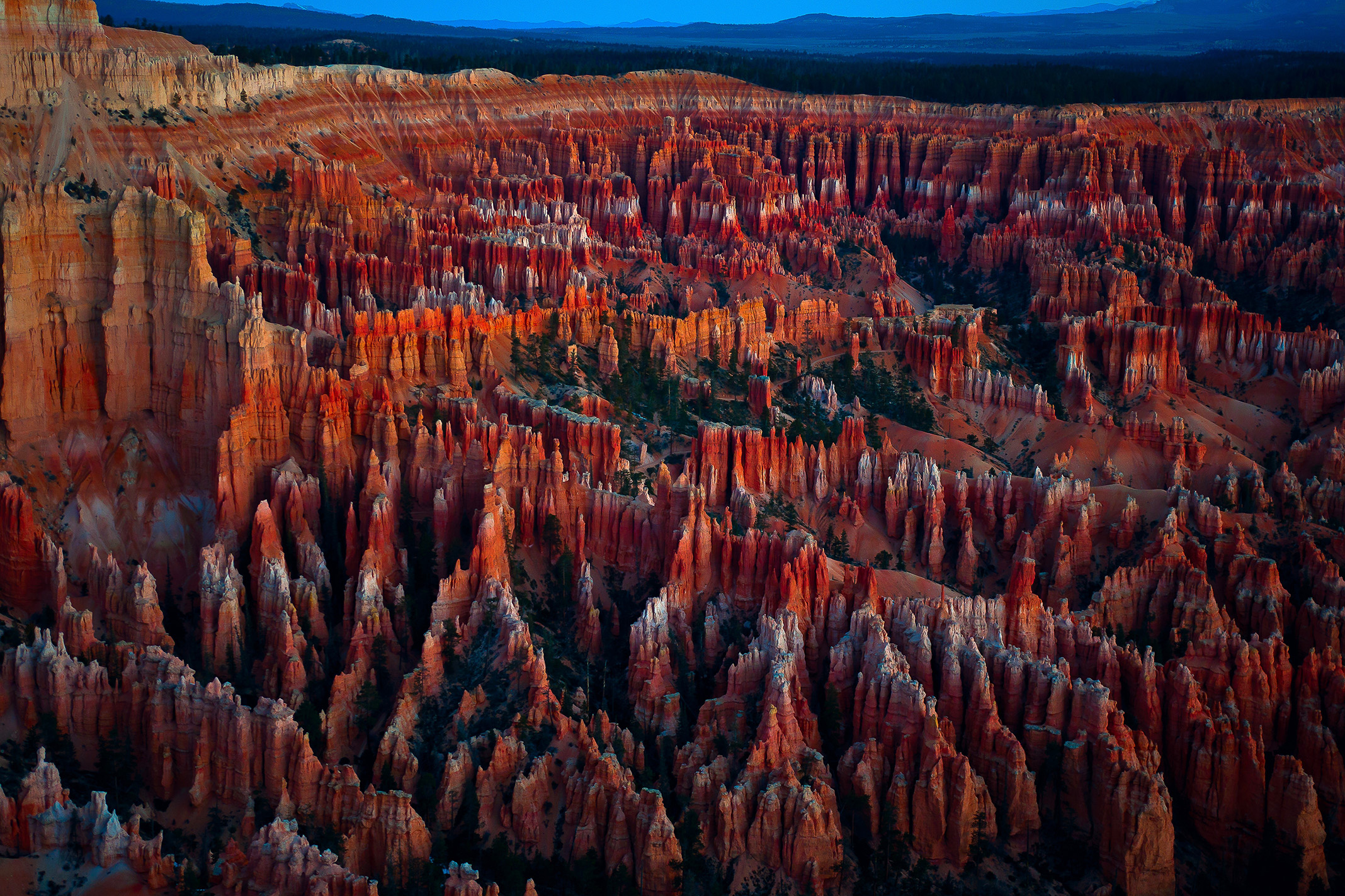
Sunrise! The amphitheater faces east, so the hoodoos catch the first direct light and glow. Sunset is pretty but lights the rim from behind, so the colors are flatter. Despite the "Sunrise Point" name, Dustin highly prefers and recommends Inspiration Point for sunrise, as it gives you this great high, broad view of the amphitheater lighting up for some amazing photography opportunities. This is where our gift shop print of Bryce Canyon at dawn was taken from.
Do I need to use the shuttle? +
Not if you time it right, but during peak times if you want to get into Bryce, Inspiration, Sunrise, and Sunset points you may need to. Starting around early April, the parking lots in these areas start to fill by mid-morning and the rangers will begin to turn you away. It would really be a shame not to get into one of these overlooks, because you can't see the amphitheater from the road and you’d miss out on the main reason for visiting Bryce Canyon. Arrive early and head straight to the overlook to ensure a parking spot, or plan to take the shuttle.
Can I visit Bryce in winter? +
Yes, and we'd argue it's one of the most beautiful winter experiences in the National Parks. The main park road is plowed to Inspiration Point, the rim trails are walkable in good winter boots with traction (microspikes recommended), and the orange hoodoos against fresh snow are unforgettable. However, there does tend to be winter closures on some of the trails and access points like Wall Street and parts of the Rim Trail, and the ascents and descents into the canyon are steep enough that it can be a real problem with ice, so we wouldn't recommend it as a "hiking destination" in winter like we do other times unless you’re prepared with the right gear.