Capitol Reef National Park

Capitol Reef National Park

A 100-mile wrinkle in the earth's crust where towering red cliffs meet pioneer orchards, and you can pick a peach in the only national park that lets you.

242K Acres
100 mi Waterpocket Fold
2,700 Heritage Fruit Trees
1971 Year Established

Our Take

Of all Utah's national parks, Capitol Reef was the hardest for us to describe after we left. Zion has its towering canyon walls, Bryce has its hoodoos and geology, Canyonlands has vast overlooks and wide-open spaces, and Arches has arches. Capitol Reef somehow has pieces of all of them, mixed with layers of human history and a landscape that just feels older. Sandstone walls rise straight out of dry washes, and the Waterpocket Fold runs for nearly 100 miles through the desert, as if someone picked up enormous slabs of the earth and set them back down sideways. Scattered through it all are fossilized oyster beds, Fremont petroglyphs, pioneer orchards, and dirt roads disappearing into the desert. It feels a little Old West, a little Jurassic Park, and somehow a little more remote than the other Utah parks we visited. The word we kept coming back to was prehistoric.

Capitol Reef was also where we finally slowed down on our Mighty 5 road trip, and that turned out to be exactly the right way to experience it. We hiked to Hickman Bridge, climbed across the slickrock to Cassidy Arch, drove the Scenic Drive, and watched the last light hit the Henry Mountains. We meant to take a short walk in Capitol Gorge and ended up following it all the way to the Pioneer Register, where settlers and other early travelers scratched their names into the canyon wall. Grand Wash felt like someone had crossed Park Avenue in Arches with a dry version of Zion's Narrows, with enormous sandstone walls rising on either side of you.

Some of our favorite memories came from driving farther out, though. We spent a day looping around the Waterpocket Fold, climbing the Burr Trail Switchbacks through a landscape that seemed to get emptier and stranger the farther we went. (Before we left, Dustin texted his parents instructions to call the Garfield County Sheriff if they didn't hear from us by a set time. Overly cautious, maybe, but it's a dirt road into the middle of nowhere with a kid in the back seat.) And then there's Fruita, with green orchards, old barns, and the Gifford Homestead, where we arrived too late for the cinnamon rolls and Allison and Warren settled for ice cream while I ate two small pies: cherry and strawberry rhubarb.

Capitol Reef still has a little bit of that pre-Instagram National Park feeling: get out of the car, follow a wash between the canyon walls, drive a dirt road farther than you planned, and see what you find. Just check the forecast before you do, because the washes can flash flood and the dirt roads get dicey when wet. Give it more time than you think it needs.

Things to Do in Capitol Reef National Park

Hike to Hickman Bridge

▼
Hickman Bridge is one of the best short hikes in Capitol Reef. The trail starts along the Fremont River, then climbs through black volcanic boulders and into the sandstone cliffs, passing small alcoves and opening up views across the canyon as you gain elevation. The natural bridge is the destination, but the hike there is half the reason to do it. You can walk beneath the massive sandstone span, photograph it from several angles, or use the opening to frame the landscape beyond. Arrive early; the trailhead parking lot is small, and when we visited in early April it was already full by about 8:30 a.m.

Hike to Cassidy Arch

▼
For a bigger adventure, hike Cassidy Arch. The challenging climb out of Grand Wash leads onto wide-open slickrock high above the canyon, where Cassidy Arch eventually comes into view across the sandstone. The real payoff is reaching the arch from above: you can walk directly across the massive sandstone span with Grand Wash far below, or step back and photograph it against the surrounding cliffs. There are serious drop-offs around the arch and along parts of the route, so watch your footing, especially when taking photos and selfies.

Drive the Scenic Drive

▼
Don't leave Capitol Reef without driving the Scenic Drive. The road runs south from Fruita beneath the massive sandstone cliffs of the Waterpocket Fold, with one spectacular view after another as you make your way deeper into the park. Take your time, stop along the way, and if you can, drive it later in the day when the lower light brings out the color and texture in the cliffs. Allow more time if you want to explore the dirt spur roads into Grand Wash or Capitol Gorge.

Pick Fruit in the Fruita Orchards

▼
Pick your own apples, peaches, cherries, or other fruit from the historic orchards in the middle of Capitol Reef. The orchards are remnants of the Mormon settlement of Fruita, and the Park Service still maintains roughly 1,900 trees beneath the red cliffs along the Fremont River. During harvest, the park posts which orchards are open; grab a bag, pick what you want, then weigh and pay for it before you leave. If you're visiting outside harvest season, the orchards are still worth wandering through, especially during the spring bloom.

Get Pies and Explore The Gifford Homestead

▼
Stop at the Gifford Homestead for a fresh-baked fruit pie, then grab a picnic table beneath the trees and eat it surrounded by the orchards and red cliffs of Fruita. The small shop inside the historic farmhouse also sells homemade ice cream, jams, and other local goods, while rooms in the house are preserved to show what life was like for the families who farmed here. Get there early if you have your heart set on something; we arrived too late for the cinnamon rolls and had to console ourselves with ice cream and two small pies.

See the Fremont Petroglyphs

▼
Stop along Highway 24 to see petroglyphs carved into the sandstone cliffs by the Fremont people hundreds of years ago. A short boardwalk leads beneath panels filled with distinctive human figures, bighorn sheep, and other designs, some surprisingly high on the cliff face. The whole stop takes about 10–15 minutes and is right off the road, making this one of the easiest things to fit into a day at Capitol Reef. Bring binoculars if you have them; some of the best figures are much easier to see with a little magnification.

Hike Capitol Gorge to the Pioneer Register

▼
Drive the dirt road into Capitol Gorge, then follow the canyon on foot to the Pioneer Register, where 19th- and early-20th-century travelers carved their names and dates into the sandstone walls as they passed through the Waterpocket Fold. We almost dismissed the register as a minor historical stop, but seeing names carved high above the canyon floor and realizing people had been passing through this same narrow corridor for generations made it much cooler than we expected. The walk itself is easy and mostly flat, with the towering walls of Capitol Gorge surrounding you the entire way.

Loop The Fold

▼
Drive the Loop-the-Fold to see just how big and varied Capitol Reef gets beyond Fruita. The route circles the southern end of the Waterpocket Fold through huge, empty landscapes that feel almost prehistoric, with colorful badlands, tilted sandstone cliffs, long stretches of dirt road, and some of the best photo opportunities in the park. The Burr Trail Switchbacks are a highlight, climbing dramatically up the face of the Fold in a series of tight turns. Give yourself 6–8 hours with stops, and check current road conditions and vehicle recommendations before heading out; this is a remote drive where weather can quickly change the roads.

Explore Cathedral Valley

▼
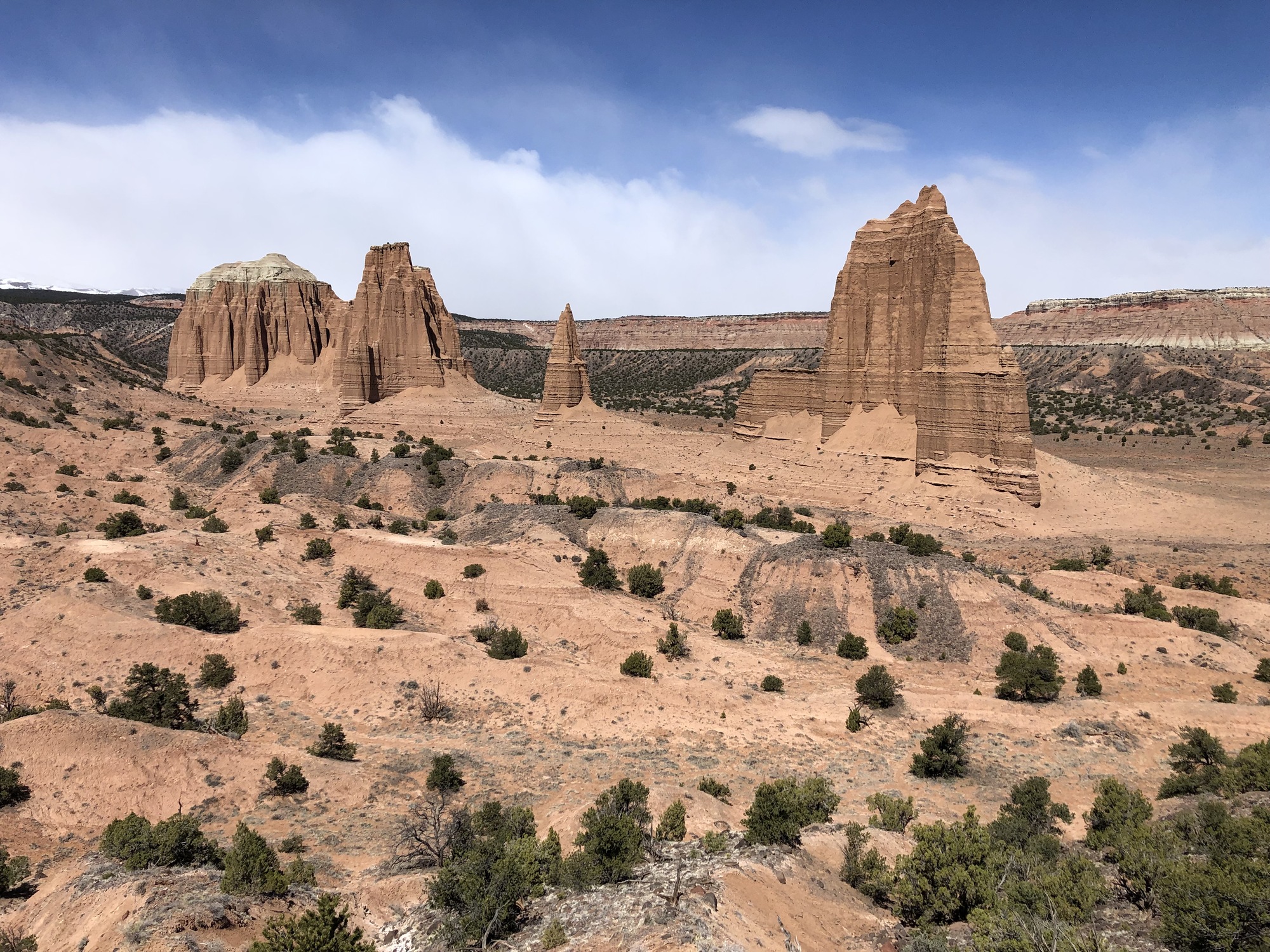
Cathedral Valley is Capitol Reef at its most remote, with miles of empty backcountry leading to enormous sandstone monoliths rising almost alone from the desert floor. The Temples of the Sun and Moon are the stars, but getting there is part of the adventure: the full loop is nearly 60 miles of dirt road and, driven clockwise, starts by fording the Fremont River. Plan on 6–8 hours for the full loop and bring a high-clearance vehicle. Check road, weather, and river conditions before you go; rain can quickly make these roads impassable.

Watch the Sunset from Sunset Point

▼
It's called Sunset Point for a reason. The view looks across Capitol Reef toward the distant mountains rather than directly into the setting sun, so the show is the changing light on the cliffs and rocks below and whatever color develops across the evening sky. Get there with time to spare, both to find parking and to walk around the overlook for different compositions; the landscape you're photographing is farther away than it first appears. Don't expect solitude, but there's enough room to move around and find your own perspective.

Visit Goblin Valley State Park

▼
If you have an extra half day, make the trip out to Goblin Valley State Park. Thousands of strange, mushroom-shaped hoodoos fill the valley, and unlike most places with fragile formations, you can leave the trail and wander right through them. It's especially fun with kids, who can turn the whole valley into a giant natural playground. Goblin Valley is about 90 minutes from Fruita, so it isn't a quick Capitol Reef detour, but it's an easy addition if you're continuing east toward Hanksville or Moab.

Tips for Visiting Capitol Reef National Park

1

Don't Treat Capitol Reef As A One-Day Park

Capitol Reef is a long, narrow park, and its three main areas are far enough apart that you can't see them all in a day. Fruita and the Scenic Drive sit in the middle, Cathedral Valley stretches to the north, and the Waterpocket District runs south. Fruita alone can easily fill two days with hikes like Hickman Bridge and Cassidy Arch, Grand Wash and Capitol Gorge, the Scenic Drive, and the historic district. Cathedral Valley is typically a six-to-eight-hour loop and requires high clearance, a river crossing, and potentially 4WD depending on conditions. Loop-the-Fold through the southern end took us a full day and ended up being one of our favorite days of the trip. If you only have one day, stick mostly to Fruita. With three or more, you can slow down and add a day or two farther out.
2

Know Where Your Vehicle Can Take You

Much of Capitol Reef is accessible without a 4WD. Highway 24, the Scenic Drive, Grand Wash and Capitol Gorge are normally accessible by passenger car, and in good conditions you can drive Loop-the-Fold without a high-clearance vehicle. High clearance and/or 4WD is recommended for Cathedral Valley, including its Fremont River ford, as well as Strike Valley and Halls Creek overlooks. Road requirements can change with conditions, so check with a ranger before heading into the backcountry and be prepared to turn around.
3

Watch The Weather Closely

Weather can change quickly at Capitol Reef, and rain can create dangerous conditions well beyond where it's actually falling. Flash floods are a serious risk in Grand Wash, Capitol Gorge, and other narrow drainages, while unpaved roads can quickly become muddy and impassable, even with 4WD. Check the forecast before hiking a wash or heading into the backcountry, and check current road conditions before any of the park's longer scenic drives.
4

Download Maps Before You Go

Cell service is available around Torrey, but don't count on it once you're inside Capitol Reef, especially when you head south into the Waterpocket District or north into Cathedral Valley. Even GPS routing isn't something you want to rely on here. Download offline maps in Google Maps and your AllTrails routes before leaving Torrey, and pick up a paper map at the visitor center if you're planning to explore the backcountry.
5

Time Your Visit Around Fruita's Pies And Orchards

The Gifford Homestead is seasonal, so check its opening dates and hours before your trip. When it's open, it's known for its pies and cinnamon rolls, and the most popular items can sell out, so stop early if there's something you really want. If you're visiting during harvest season, also check which Fruita orchards are open for picking. Cherries and apricots start in early summer, peaches and pears follow, and apples can run into October depending on the year.
6

The Entrance Fee Only Applies to the Scenic Drive

You don't pay an entrance fee just to drive into Capitol Reef. Highway 24, the visitor center, Fruita, Hickman Bridge, the petroglyphs, and the Gifford Homestead are all before the fee station. The $20 vehicle fee applies when you drive past the Fruita Campground onto the Scenic Drive, where there's a self-pay station. If you have an America the Beautiful pass, you're covered.

Best Time to Visit Capitol Reef National Park

Our pick: Mid April or Late September.

We visited in early April and had nearly ideal conditions: comfortable hiking temperatures and no summer monsoon storms to plan around. Spring also works especially well if Capitol Reef is part of a larger Mighty 5 road trip, but keep an eye on conditions at higher elevations, especially Highway 12 over Boulder Mountain, where snow is still possible.

For photography, we'd lean toward late September into mid-October. Cottonwoods along the Fremont River begin turning gold, apples ripen in the Fruita orchards, and the lower fall sun gives better light for more of the day. Monsoon storms can linger into early fall, so watch the forecast if you're planning wash hikes or backcountry drives.

Average Park Visitors by Month

Temperature by Month

Cold (< 55°F)
Ideal (55-80°F)
Hot (> 80°F)
Average

Getting to Capitol Reef National Park

Visitor Centers

1

Capitol Reef Visitor Center

Located at the junction of Highway 24 and the Scenic Drive in the Fruita Historic District, the visitor center has exhibits on the Waterpocket Fold and the human history of the area, a bookstore, ranger-staffed information desk, and restrooms. This is a good first stop to check which orchards are open for picking and current road conditions, especially if you're heading into Cathedral Valley or the Waterpocket District.

Entrances

1

Highway 24 From Torrey (West Entrance)

The most common way in. Highway 24 enters the park a few miles east of Torrey and cuts straight through the Fruita area, passing the visitor center, the orchards, and major trailheads. There's no entrance station; fees are only collected for the Scenic Drive.
2

Highway 24 From Hanksville (East Entrance)

Coming from the east, Highway 24 continues from Hanksville about 37 miles to the Capitol Reef Visitor Center. There's no entrance station on Highway 24—you simply drive into the park, with pullouts, overlooks, and trailheads along the way.
3

Cathedral Valley (North)

Accessed via the Hartnet Road (11.7 miles east of the visitor center) or Cathedral Road, also called Caineville Wash Road (18.5 miles east). Both are dirt and require high clearance, and 4WD is often recommended. The Hartnet Road begins with a ford of the Fremont River that shouldn't be attempted in high water; check conditions at the visitor center first.
4

Burr Trail / Notom-Bullfrog Road (South)

The southern Waterpocket District is reached via the Burr Trail from Boulder or the Notom-Bullfrog Road, which leaves Highway 24 about 9 miles east of the visitor center. Both are paved for part of the way and graded dirt inside the park. The Burr Trail Switchbacks aren't suitable for RVs or trailers, and we'd only drive them in dry conditions.

Entrance Fees

Vehicle (Scenic Drive)
$20
Motorcycle (Scenic Drive)
$15
Person/Bicycle (Scenic Drive)
$10
Capitol Reef Annual Pass
$35

Where to Stay

Gateway Towns

8
mi west

Torrey Our Pick

Torrey is the obvious base camp for Capitol Reef and the place we'd recommend staying for almost any visit. The town has a surprisingly good mix of independent restaurants, lodging that ranges from budget motels to restored historic schoolhouses to glamping setups, and a general store for groceries and supplies. You're about 15 minutes from the park visitor center, and Highway 12 begins right outside town.
Best for: First-timers, families, anyone who wants restaurants and amenities within five minutes of the park entrance.
37
mi east

Hanksville

A smaller, dustier desert town on the east side of the park, Hanksville is a useful base if your trip extends beyond Capitol Reef into the surrounding desert. Lodging is limited compared with Torrey, but staying here puts you closer to Goblin Valley State Park, the Bentonite Hills and Factory Butte, the Henry Mountains, and the long empty stretches of Highway 95 toward Lake Powell.
Best for: Budget travelers, RV travelers, anyone combining Capitol Reef with Goblin Valley, Factory Butte, Moon Overlook, or Lake Powell.
Click here to check out our curated list of the best lodging outside the park.

Frequently Asked Questions

Is there an entrance fee?

+

Sort of, but probably not the way you're thinking. Most of Capitol Reef — including Highway 24 through the park, the visitor center, Fruita, the orchards, the Hickman Bridge trail, and the petroglyph panel — is completely free to drive through and visit. The $20 vehicle fee only applies if you drive past the Fruita Campground onto the <em>Scenic Drive</em>, where there's a self-pay station. If you have an America the Beautiful pass, it covers the Scenic Drive too.

When can I pick fruit at Fruita?

+

The harvest schedule changes a bit each year depending on weather, but the general windows are: cherries in mid-to-late June, apricots in late June through mid-July, peaches and pears in August, and apples from early September into October. The visitor center keeps an up-to-date list of which orchards are currently open for picking, and trees can close suddenly when the fruit is gone. If picking is the reason you're coming, make the visitor center your first stop and ask the rangers — they'll point you to the right orchard.

Can I do Capitol Reef in one day, or how much time do I need?

+

Yes, but we'd recommend at least two to three days. One day gives you enough time for Fruita, the Scenic Drive, a short hike like Hickman Bridge, and sunset. Add another day if you want to do more hikes or drive Cathedral Valley or the Loop-the-Fold, both of which can take most of a day on their own.

Do I need a 4WD or high-clearance vehicle?

+

For the central Fruita section and the Scenic Drive, no — any passenger vehicle is fine, including the dirt extension into Capitol Gorge in dry conditions. For Cathedral Valley to the north or the Burr Trail Switchbacks and Notom-Bullfrog Road to the south, you'll want high-clearance and ideally 4WD, especially if conditions are at all wet. The Hartnet Road into Cathedral Valley also begins with a low-water ford of the Fremont River that should not be attempted after rain.

Can I camp in the park?

+

Fruita Campground is the only developed campground in Capitol Reef, and it's worth the effort to get a spot — it sits right in the orchards along the Fremont River, with cottonwoods overhead and easy walking access to the visitor center and most of the central park trails. It takes reservations on Recreation.gov from March through October, and reservations book up months in advance for peak season. Outside of peak season it can be first-come first-served. There are also primitive (no water, no fee) campgrounds in Cathedral Valley and Cedar Mesa for those venturing into the backcountry.